THINGS TO DO · YOUTUBE SHORT
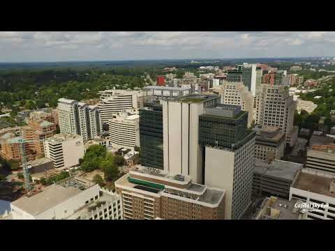
Bethesda Aerial Tour
An aerial tour of downtown Bethesda around the Wisconsin Avenue, Old Georgetown Road and East-West Highway intersection.
Watch on YouTube ↗
Outdoors
39 national forests, lakes, parks and campgrounds within reach, by activity.
26 places · closest 4 mi
Carderock Recreation Area Pavilion, Rock Creek Park and more
Best: February–May, September–December
18 places · closest 4 mi
Carderock Recreation Area Pavilion, Rock Creek Park Group Picnic Areas (DC) and more
Best: March–June, September–November
11 places · closest 4 mi
Carderock Recreation Area Pavilion, Chesapeake & Ohio Canal National Historical Park and more
8 places · closest 4 mi
Rock Creek Park, Chesapeake & Ohio Canal National Historical Park and more
Best: April–October
21 places · closest 2 mi
George Washington Memorial Parkway, Rock Creek Park and more
Best: February–June, September–December
15 places · closest 2 mi
George Washington Memorial Parkway, Civil War Defenses of Washington and more
Best: April–June, August–October
23 places · closest 2 mi
George Washington Memorial Parkway, Rock Creek Park and more
19 within 37 mi · closest 5.4 mi
Fishing Shore, Purplehorse Beach and more
7 within 37 mi · closest 4.3 mi
Stubblefield Falls, Scott's Run Falls and more
30 within 30 mi · closest 3.1 mi
Dalecarlia Reservoir, Georgetown Reservoir and more
30 within 37 mi · closest 4.4 mi
Stubblefield Falls Overlook, Freedom Park Viewpoint and more
4 within 75 mi · closest 44.9 mi
Charles Town Cave, Crystal Grottoes and more
Map of 39 places loads as you scroll.
THINGS TO DO · YOUTUBE SHORT
An aerial tour of downtown Bethesda around the Wisconsin Avenue, Old Georgetown Road and East-West Highway intersection.
Watch on YouTube ↗
THINGS TO DO · YOUTUBE SHORT
A quiet ride through Bethesda’s central business district.
Watch on YouTube ↗Places come from Recreation.gov’s federal recreation database; distances are straight-line miles from the center of Bethesda.